NEWSPORT LIVE BLOG: Eerie calm and silence descends on Douglas Shire as residents await Cyclone Jasper
TUESDAY

4.32PM: Thank you and good afternoon
That wraps up today's Cyclone Jasper rolling coverage on Newsport. I'll re-join you tomorrow morning QLD standard time to bring you all you need to know about Jasper making landfall in the Douglas Shire.
If we start to get heavy rainfall later tonight, I'll endeavour to bring you some video or pictures - so make sure you stay tuned to both the Newsport website and our Facebook for the absolute very latest.
Thanks for your company, we'll see you tomorrow when Cyclone Jasper makes its way across the Douglas Shire.
--
4.27PM: Douglas Shire current conditions
There's an eerie vibe across the Shire with current conditions, overcast, with little wind. As it stands, it remains extremely humid. Port Douglas's main street, Macrossan St, is basically deserted while traffic is minimal across most of the Douglas Shire.
At this stage some weather experts have Jasper making landfall anywhere from 2pm-6pm tomorrow, December 13, Queensland standard time.
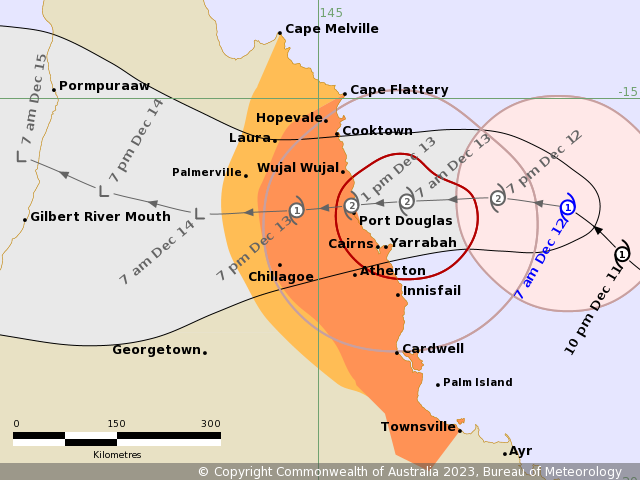
At this stage BOM statellite imagery has Jasper crossing the coast in the Wujal Wujal or Bloomfield area, however its trajectory continues to change minute to minute.
--
4.02PM: Council clarifies Douglas storm tide surge zone confusion
Council has advised Douglas Shire residents that remain confused about what storm tide surge zone their currently in to visit the Douglas dashboard. Those in the red zone are at greatest risk followed by orange and yellow.
Council says residents will be advised based on the zone they are required to evacuate.
--
3.58PM: 'We're sorry' - Douglas Shire Council apologises for sandbag fiasco
"The safety of community members is Council's priority and we apologise for any confusion this morning," a Council spokesperson told Newsport just moments ago.
"Understandably, there's been an overwhelming demand for sand across the shire as people prepare their homes and businesses for TC Jasper.
"The sand at Port Douglas sports complex is available for public use."
--
1.11PM: Thousands flock to Newsport's Cyclone Jasper coverage
Yesterday proved a watershed day for Newsport with thousands right throughout the day and into the evening tuning into our live Cyclone Jasper blog coverage from around the world.
By midnight last night we had recorded near record figures for a single day of readership.
Thank you for your ongoing readership and loyalty as we bring you the very latest regarding Cyclone Jasper.
A quick glance at our metrics saw thousands of readers accessing our content from around the Douglas Shire, across Australia and right around the globe.
Those locations included America, Austria, Canada, Switzerland, Spain, France, India, Solomon Islands and the United Kingdom.
--
1.05M: Newsport's EXCLUSIVE Cyclone Jasper live video/camera action
A reminder over the next few days as Cyclone Jasper makes landfall over the Douglas Shire be sure to tune in LIVE to our Four Mile Beach and Palm Cove beach cameras.
Both cameras are perfectly positioned to showcase the heavy rainfall and wind expected across the region over the next few days. Whether you're based in the Douglas Shire, interstate, or overseas, you won't miss a beat by simply clicking the below links and watching the cyclone do its thing.
You can view Newsport's exclusively located cameras by clicking here: https://www.newsport.com.au/beachcam - PORT DOUGLAS and https://www.newsport.com.au/beachcam/palm-cove-beachcam - PALM COVE
--
1.02PM: Cairns airport latest
“Preparations continue at Cairns Airport as we await the arrival of Tropical Cyclone Jasper. We are following procedures outlined in the Cairns Airport Cyclone Plan, in line with advice from the Bureau of Meteorology and relevant local authorities," Cairns Airport chief executive officer Richard Barker said just moments ago to Newsport.
“As such, Cairns Airport operations are progressively winding down and will likely cease on Tuesday evening.
"Our domestic and international terminals will not be open on Wednesday 13 December. Please do not come to Cairns Airport on Wednesday. Cairns Airport operations will recommence when it is safe to do so. Updates will be provided regularly through the Cairns Airport Facebook page and via our website.”
“A number of airlines have cancelled or rescheduled services. Customers are advised to contact their airline with any specific enquiries. Cairns Airport continues to conduct regular Cyclone Committee meetings, which include representatives from key operational stakeholders, including airlines and Airservices Australia. The Cairns Airport community is well briefed and prepared.”
--
12.47pm: Douglas Shire residents and holiday makers ahead share thoughts and insights ahead of Jasper's arrival
John and Julie Tripp, residents of Port Douglas for the past year, shared their preparations and sentiments ahead of the impending cyclone.
“We’ve stocked up on water and some cold food, just in case the power goes out. We’ve also secured my boat down the creek, tied to the mangroves, so hopefully, it’ll be safe there," John said.
“We’re trying to stay calm and wait it out. This is our first cyclone; we’ve only been here for 12 months. But looking around, everyone else seems fairly calm, so that's reassuring.
"We’re not overly concerned. Our apartment is on the first floor, so we’re somewhat removed from the immediate danger. Plus, the building is sturdy, so we feel quite secure here.”
-
Jimmy and Jeanette Roe, tourists from the UK visiting their son in Port Douglas, are eagerly looking forward to the cyclone during their stay, and are anticipating the cyclone during their visit.
“Experiencing a cyclone is new for us and we’re quite intrigued and looking forward to it," Jeanette said.
"To prepare, we made sure to stock up on food for ourselves and our dogs. Additionally, we took the advice to heart and made sure to have an ample supply of toilet rolls on hand.”
-
Raine Ward and Mykaylah Raseta from Maker, recently opened in their new location on Macrossan Street, shared their thoughts on preparing for the cyclone.
"Being in a completely new store, it's somewhat unfamiliar territory," Raine told Newsport.
"I've taken precautions like sandbagging at the front and back doors to reduce the risk of flooding from the nearby hill. That's my primary concern. Overall, though, I feel pretty confident, especially in this new building designed with safety in mind.
“I’ve experienced a few cyclones before; this would be my third. During Cyclone Yasu in 2011, we all gathered at my parent’s house in Shannonvale. About 20 of us bunkered down, even hiding under a dining table when it got a bit scary. Fortunately, we all came out fine.”
-
Rowan Milner and Nunnicha Toosanran, owners of Nicha’s Coffee on Macrossan Street, have taken precautions in preparation for the approaching cyclone.
"We had to dismantle our awning, which was flapping, so we’re prepared for that to avoid having to replace it. All the bins are secured under the car park and we’ve checked the drains, so we’re all set," Rowan said.
"This will be our first cyclone experience up here. While we’ve encountered plenty of storms in Victoria, experiencing a cyclone is a new phenomenon for us.”
-
Rita Feening, who works at Piccolo in Port on Macrossan Street, is grappling with a bit of anxiety as the cyclone approaches.
“It’s a bit unnerving not having experienced something like this before, especially considering our location," Rita told Newsport.
"The worrisome part is knowing our places are at risk. Dealing with the wind, I believe we’ll manage; we just have to wait and see how things unfold. I’ve lived up here for three years now, so this will be my very first cyclone.
“We’ve gathered sandbags, stocked up on plenty of water, and non-perishable food. Since we live close to the pool and in a tidal surge zone, we’ve also backwashed it. So, we’re just doing the best we can.”
- Compiled by Jamie Jansen
--
12.43PM: Your pictures, photos and footage
As the afternoon continues and the impact of Jasper starts to be felt feel free to comment us your photos and footage of rainfall, damage or anything you want to show other Douglas Shire residents. Your contributions are invited and very welcomed. Use our current newsblog on our Facebook page to show us your photos.
--
12.38PM: Rainfall
Moderate to heavy rain now falling in Douglas Shire, including Macrossan St in Port Douglas.
--
12.33PM: Latest Jasper tracking
Latest BOM satellite imagery has Cyclone Jasper making landfall between Port Douglas and Wujal Wujal, however its trajectory continues to change minute by minute.
--
12.31PM: Sandbag info
Newsport understands Papillon Landscapes and Raw and More have donated 500 sandbags after all of Council's allocation have been exhausted by Douglas Shire community members.
--
12.29PM: Latest BOM Cyclone Jasper advice
Just moments ago BOM confirmed Jasper remains at a Category 1 cyclone with sustained winds near the centre of 85 kilometres per hour and wind gusts to 120 kilometres per hour.
Jasper is currently located 245km east Northeast of Cairns and is moving at 12km an hour.
BOM has pointed to Jasper potentially re-intensifying tonight as it moves towards the coast.
It is forecast to cross the coast as a category two system tomorrow most likely between Cooktown and Cairns.
Bom has reminded Douglas Shire residents local intense rainfall may lead to dangerous and life-threatening flash flooding between Cape Flattery and Port Douglas, as well as areas near the centre of Tropical Cyclone Jasper.
As the cyclone approaches the coast a storm tide is expected between Cooktown and Lucinda on the high tides today and tomorrow.
Large waves may produce minor flooding along the foreshore.
People living in areas likely to be affected by this flooding should take measures to protect their property as much as possible and be prepared to help their neighbours.
--
12.19PM: Douglas Post Office closure
Port Douglas has kindly requested Douglas Shire residents to pick up their parcels before 2pm today.
Douglas Post Office staffers have confirmed The Post Office will be closed tomorrow, December 13.
--
9.24AM: Douglas Shire high tide reminders
A reminder about the upcoming high tides over the next few days in the Douglas Shire. Tomorrow's high tide will take place at 9.19am and reach 2.82 metres.
Thursday's high tide will be at 10.04am and reach 2.82 metres. On Friday, the high tide will occur at 10.55am. Keep in mind that Cyclone Jasper is expected to create an onset of storm surges, so please exercise extreme caution around local beaches and waterways.
--
9.03AM: Douglas Shire Christmas party cancelled, carols still scheduled to proceed Saturday night
This Friday's Douglas Christmas street party has been cancelled due to Tropical Cyclone Jasper and subsequent heavy rains forecast.
“At this stage the Douglas Shire Christmas Carols are going ahead, so hopefully we can come together on Saturday night to share some festive spirit," Cr Kerr said.
--
9.01AM: Douglas Shire kerbside bin collection latest
Douglas Shire Council has confirmed kerbside waste and recycling collection will still take place today Tuesday, December, 12. There will be no kerbsire bin service tomorrow, Wednesday, December 13.
--
8.44AM: QFES staff arrive in Far North to assist with Jasper response
Around 100 Queensland Fire and Emergency staff and volunteers continue to arrive in the Far North to tackle the aftermath of Cyclone Jasper.
Those travelling to the Far North and that will assist Douglas Shire residents over the next few days include fire and rescue service swiftwater rescue technicians, incident management specialists, technical support officials and SES volunteers.
In addition 25 officials from the Brisbane based Disaster Assistance Response Team (DART) are about to depart for Cairns in response to TC Jasper.
--
8.40AM: Ergon Energy at the ready for Douglas Shire residents
Ergon Energy has activated its emergency management plan and placed staff on standby in preparation for responding to any network damage and power outages from Cyclone Jasper.
Emergency containers of equipment have been dispatched to key locations as part of Ergon Energy’s preparation and response efforts.
Staff across North Queensland are preparing vehicles, equipment and making final checks of major substations and electrical infrastructure.
Chief Operating Officer, Paul Jordon said crews will begin any power restoration effort as soon as the cyclone has passed, and it is safe for our people move into the field.
“Our customers and communities can rest assured staff are ready for the response effort - we have more than 450 field crews across Queensland available if required," he said.
“Our crews are extremely well prepared for the cyclone and any subsequent damage it causes. Our Emergency Management Plan is updated and rehearsed regularly across the organisation.
"We continue to train our staff both in the field and in support services in disaster scenarios to ensure they remain familiar with the plan and can implement it effectively.
"Ergon Energy representatives have been co-ordinating efforts with local and state disaster agencies for potential impacts from Cyclone Jasper.
“If the cyclone causes major outages, we will quickly bring in back-up resources from other regions, which are already on standby to provide additional capacity.
"This will allow for prompt restoration work and an effective roster rotation to relieve crews that have been working extended hours to help restore power to impacted communities.
“Our Contact Centres and Network Control Centres are being staffed in a similar way to ensure appropriate resourcing is in place.
“The safety of the communities we serve as well as our staff is our top priority in any restoration program. We will do whatever it takes to ensure power is restored safely and as quickly as possible.
“Ergon Energy’s territory includes the state’s most cyclone prone areas, so maintaining capabilities to cope with the cyclone and storm season remains an ongoing priority each year."
--
8.37AM: Locals allegedly denied critical sand
A picture has emerged just moments ago of on site security guards allegedly stopping locals from attaining sand or sandbags near the Crocpit in Port Douglas. We’ve reached out to DSC for clarification and comment around this matter.
--
8.24AM: Latest Cyclone Jasper BOM advice
Just moments ago BOM confirmed Cyclone Jasper is of Category 1 Intensity and has sustained winds near the centre of 85 kilometres per hour, with wind gusts to 120 kilometres per hour.
Jasper is estimated to be 265 kilometres east northeast of Cairns and is moving northwest at 14 kilometres per hour.
Tropical Cyclone Jasper is expected to re-intensify today as it moves west northwest towards the coast.
It is forecast to cross the coast as a category two system on tomorrow, most likely between Cooktown and Innisfail.
Jasper will weaken as it moves inland during Thursday towards the Gulf of Carpentaria
Destructive winds of up to 140 km/h are expected to develop between Wujal Wujal and Innisfail, including Cairns from early tomorrow morning.
Gales with damaging winds of up to 120 km/h are expected to develop along the Queensland coast and adjacent ranges between Cape Flattery and Townsville, including Cairns, from this afternoon.
These damaging winds are expected to extend inland to Palmerville and Chillagoe after the cyclone has crossed the coast on Wednesday.
Heavy rainfall which may lead to flash flooding is forecast to develop from early Wednesday morning between Cape Flattery and Ingham.
Six-hourly totals between 100 to 150 mm are likely, with isolated falls of 250 mm possible along the coast and adjacent ranges. 24-hourly rainfall totals between 150 to 250 mm are likely, with isolated falls up to 350 mm possible.
As the cyclone approaches the coast, a storm tide is expected between Cooktown and Townsville on the high tides today and Wednesday.
Large waves may produce minor flooding along the foreshore. People living in areas likely to be affected by this flooding should take measures to protect their property as much as possible and be prepared to help their neighbours.
--
8.20AM: Good Morning, I'm Michael Warren, welcome to Newsport's live blog and rolling coverage as the Douglas Shire awaits the arrival of Tropical Cyclone Jasper.
From the Daintree to Douglas, Cooya to Craiglie, we'll have all the information you need to know throughout the day right here on Newsport.
It doesn't matter if you're based at Newell Beach, Whyanbeel, or Wangetti, we've got you covered re all things Cyclone Jasper.
--
Thank you!
Newsport thanks its advertising partners for their support in the delivery of daily community news to the Douglas Shire. Public interest journalism is a fundamental part of every community.
Got a news tip? Let us know! Send your news tips or submit a letter to the editor here.
* Comments are the opinions of readers and do not represent the views of Newsport, its staff or affiliates. Reader comments on Newsport are moderated before publication to promote valuable, civil, and healthy community debate. Visit our comment guidelines if your comment has not been approved for publication.