Tropical Cyclone Maila threatens another hit to Far North Queensland
Weather Watch
Far North Queensland could be in the firing line of a second cyclone in the space of just weeks, with Tropical Cyclone Maila rapidly intensifying in the Solomon Sea and the forecast that it could become a severe system within days.
Some uncertainty remains over the path Tropical Cyclone Maila could take but there is a risk the system could smash into Far North Queensland as a category three this week.
The Bureau of Meteorology has measured sustained winds of 130 kilometres per hour near the cyclone's centre, with wind gusts up to 185 kilometres per hour.
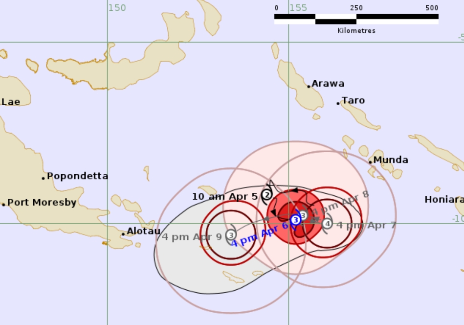
At 4pm on Monday, April 6, the Bureau indicated Severe Tropical Cyclone Maila, 37U, is currently located in the Solomon Sea. The steering influences are balanced and Maila is expected to be slow moving over the Solomon Sea before moving west southwest by Thursday.
“Maila is expected to remain well away from the Queensland coast during the next few days, but confidence is increasing in Maila moving towards the Far North Queensland coast later in the week, potentially crossing the coast on the weekend,’’ the Bureau’s update said.
There are no watch zones issued at this stage.
Australia’s 2025–26 cyclone season has already been an active one. Severe Tropical Cyclone Narelle hammered three states in March, sparing Far North Queensland from major damage but with flooding isolating large areas including the Northern Peninsula Area by cutting off Jardine Road and keeping the Jardine River Ferry out of action so far this year.
The ferry already is not expected to be operational until April 13, with more rainfall sure to delay its return to service.